
Kansas Street Walkthrough
A street search in Kansas begins with a parcel, not a list of every person at each door. First work out which Kansas county contains the address. Use that Kansas county's appraiser to find the parcel and owner shown in the public record, then carry its parcel ID and legal description into the Kansas county GIS and Register of Deeds search. A voter record can confirm one named registrant, while a historical directory can add a dated household clue. None of these sources alone proves that every listed person lives there now. This Kansas street directory workflow keeps the parcel trail separate from the household evidence.
- Enter the full or partial address in the Kansas county appraiser's property search. Save the situs address, owner name, owner mailing address, parcel number, and legal description, if shown.
- Open that parcel in the same Kansas county's GIS. Check the map label and layers, then note whether the mapped parcel matches the address you meant to research.
- Search the Kansas Register of Deeds by the current owner's name and legal description. Follow the grantor and grantee names backward through the recorded documents.
- For one named person, use the Kansas VoterView portal with the required name and birth date fields. It confirms a person's registration record; it is not a Kansas street roster.
- For an earlier household, ask a Kansas local library or archive for the city directory's street section or criss-cross pages, then compare the listed year with Kansas maps and census material.
Write down the source, search date, and exact address spelling at each step. Kansas has no statewide parcel portal that replaces the county layer, and a city address may fall outside that city's boundary. If an online result does not fit, keep the chain moving through the named custodian rather than treating an empty screen as proof that no record exists.
Kansas Parcel Search Fields
Johnson County's AIMS map is a useful Kansas example because the guide documents several ways to reach the same parcel. It is a Kansas county tool, not a statewide search. An owner name can be a person, trust, estate, or business, so compare the result with the situs and legal description before assuming that a name identifies an occupant. A parcel identifier is often the cleanest bridge between the map and the property card. A Kansas street directory search can start with the address field, but the property card is what links that search to the parcel.
| AIMS search | What to enter or inspect | How it helps |
|---|---|---|
| Address | Full or partial Kansas address; the guide gives “111 S Cherry” as an example | Finds a parcel when the current Kansas street form is known |
| Owner | Name search, with “Smith, John” as the guide example | Can locate a Kansas parcel when the address is uncertain |
| Property ID | Johnson County parcel identifier; the guide example is DP36980000 0001 | Links the Kansas map selection to the property card |
| Location | Township, range, section, AIMS map, Kansas city, or intersection | Helps with Kansas rural land or map context |
| ZIP | Kansas postal ZIP search | Narrows county parcels, not Kansas city limits |
| Property card | Kansas Tax Property ID, situs, Owner 1/2, owner address, mortgage, appraisal and tax tabs, acres, year built, class, LBCS function, neighborhood code, KUPN, taxing unit, zoning | Separates a Kansas parcel's site address from the owner's mailing address |
The Johnson guide reports type-ahead after three characters for its first four search modes. The Johnson County AIMS public map shows the documented search and identify workflow. Its search options should not be projected onto other Kansas counties, whose appraiser systems and fields differ.
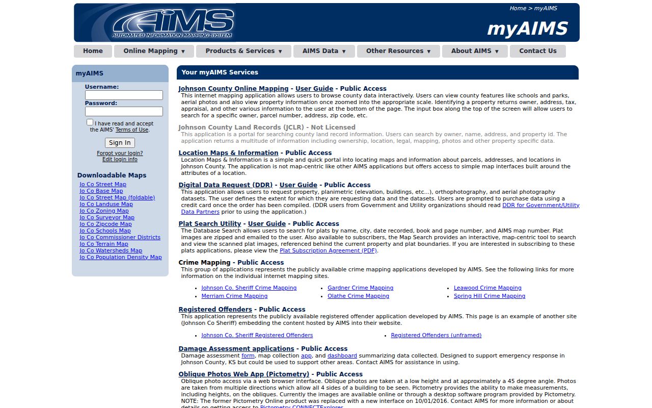
Use the situs address to locate the property and the mailing address as a separate owner clue. A mismatch is common and does not establish where a person sleeps or who else shares the address.
Kansas GIS Map Limits
Sedgwick County, Kansas Mobile Land Records help documents a practical street-browse path: search a full or partial address, parcel ID, or intersection, or click the map; device location is another option. Selecting a result opens parcel characteristics. The map also offers Kansas parcel, zoning, and flood information through its layers. In Kansas, use those layers to find the next record or office, not as a legal survey or a final statement about who occupies a building. Johnson County, Kansas has its own map and parcel identify window.
The Sedgwick County GIS help page describes the map controls and the county's warning about its tax-map boundaries.
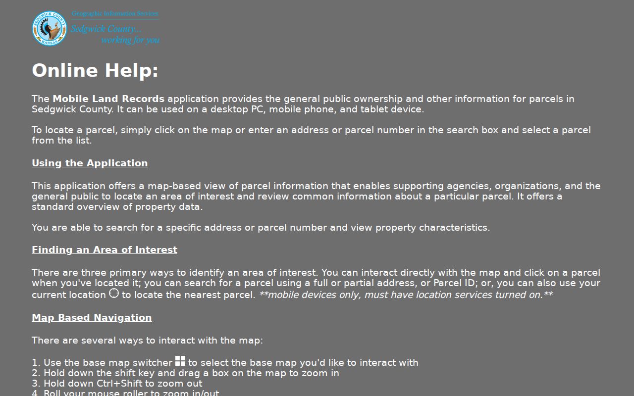
Sedgwick says parcel boundaries are tax-mapping data, generally within about three feet countywide, and are not survey evidence. Johnson AIMS has its own location search across address, property ID, owner, township-range-section, map, city, ZIP, and intersection. A road strip, drainage tract, or common area can look like a touching parcel on either map; consult the recorded plat or a survey before making a boundary claim.
Kansas Street Record Coverage
Kansas street research crosses offices that index different things. An appraiser record ties a parcel to an owner and tax details; a deed names parties to a transfer; GIS shows the mapped land; a city code layer records a case; and an old directory may list an occupant for one publication year. This Kansas street directory coverage table marks the custodian for each strand and the limits on what it says about people along a street.
| Record Set | Keeper | What It Shows | Access |
|---|---|---|---|
| Property and tax record | Kansas county appraiser and treasurer | Kansas parcel, owner, mailing address, appraisal or tax details | Kansas county property and tax search or counter; copy charges vary |
| GIS parcel map | Kansas county GIS | Kansas parcel geometry, map layers, address and parcel links | Kansas county viewer; Johnson and Sedgwick are documented examples |
| Deeds, liens, and plats | Kansas county Register of Deeds | Kansas recorded parties, legal description, transfer and plat references | Kansas county portal where offered, counter, request, or older books |
| Voter confirmation | Kansas Secretary of State or county election officer | One named Kansas registrant's status and address confirmation | Kansas VoterView by name and birth date; not street browsing |
| Permit or code case | Kansas city or county planning / code office | Kansas case address, type, status, milestone, and related parcel | Kansas local portal, GIS layer, custodian, or KORA request |
| Historic street entry | Kansas library, Historical Society, or archive | Dated Kansas name, address, household notation, and sometimes owner mark | Kansas print, microfilm, database, interlibrary loan, or reference help |
| Plat or Sanborn map | Kansas recorder, library, archive, or map collection | Kansas lot, block, street layout, or building footprint | Kansas county books or local and state collections |
Use a Kansas parcel number to connect the property card with GIS and, where supported, a city permit case; use the legal description to search deeds and plats. Kansas has no common street-name field that ties every county's records together. Address normalization, ZIP, city name, and parcel ownership can diverge across Kansas agencies, so retain the original label from each office before comparing records.
Kansas Street Deed Chain
The Register of Deeds in the Kansas county where a parcel sits records deeds and other instruments. Kansas does not have one statewide deed index, and no single online start date applies to all 105 Kansas counties. Search depth, images, fees, and vendors vary by county. The Kansas Register of Deeds Association contact map is the routing point when the county office or portal is not yet known.
Begin with the current owner from the Kansas appraiser card and the parcel's legal description. Search the owner as grantee to locate the purchase instrument. Note the grantor, recording date, book and page or document number, and any legal description. Search the grantor as a prior grantee to move back another transfer. A Kansas street name alone may miss the deed when the county index uses a subdivision, lot, block, or section-township-range description.
If a Kansas county has no public online index, ask the Register of Deeds about counter access, a written search, noncertified or certified copies, microfilm, or deed books. Kansas county fee schedules control. Record the earliest instrument located and the exact search terms that failed. Kansas county archives and libraries may hold older plat books, tax rolls, newspapers, or local ledgers that add context when an online search stops early.
- Parcel
- A mapped unit of land used by the county's property records; the county parcel number links related entries.
- Situs address
- The address assigned to the property itself, distinct from an owner's mailing address.
- Legal description
- The lot, block, subdivision, or survey language used to identify land in a recorded instrument.
- Plat
- A recorded map of lots, blocks, streets, or easements within a subdivision.
- Grantor and grantee
- The party transferring an interest and the party receiving it in a recorded document.
- Criss-cross directory
- A historical directory section arranged by street address, where the edition includes one.
Wichita Address Case Records
Wichita's Metropolitan Area Building and Construction Department (MABCD) provides a city-level branch of Kansas address research. Its portal searches zoning and subdivision cases, building permits, and related planning material. The city's inspected ArcGIS code layer links cases to an address and parcel, but a case is evidence about a municipal process, not proof that a particular person occupies the property or did anything wrong.
| Visible case field | What the Wichita layer records |
|---|---|
| Location keys | Wichita, Kansas: Address, City, ZipCode, AddressID, ParcelID, geometry |
| Case identifiers | Wichita, Kansas: OBJECTID, CaseNumber, CaseType, CASEDESC |
| Progress | Wichita, Kansas: CaseStatus, Milestone, ProcessedDate |
| Time and area | Wichita, Kansas: VioYear, VioQuarter, CENSUSBLKGRP, SubdivNM |
The Wichita MABCD ArcGIS case layer supports query, pagination, ordering, and geographic filters, with a 2,000-record maximum per result. Wichita describes an enforcement sequence from complaint and staff review through notice, a correction period, and possible referral or hearing. The case result may show dates and status; read those fields before drawing any conclusion, and ask the city custodian for the case file if the index is thin. Include this Kansas municipal layer in a street directory search only when the address is within Wichita's service area.
Kansas Voter Confirmation
Kansas VoterView can check one person's registration record, but it does not display the people registered along an entire street. The required search fields are First Name, Last Name, and Date of Birth. The result can confirm an address, party association, ballot-mail status, polling place, and districts for a matching registrant. A polling-place mode accepts a residential address to show the location, which answers a district question rather than identifying nearby voters.
| VoterView field or mode | Input | Use and limit |
|---|---|---|
| First Name | Kansas VoterView required name text | Used with last name and birth date for a Kansas person match |
| Last Name | Kansas VoterView required name text | Combined with first name and birth date in Kansas |
| Date of Birth | Kansas VoterView required date | Distinguishes records; do not publish private identity details |
| Residential address | Kansas address entry in polling-place mode | Finds a Kansas polling place when matched, not a resident list |
| View Locations | Kansas portal button | Returns polling-place information for the entered Kansas address |
The Kansas VoterView portal is a confirmation tool, not an address-wide lookup. K.S.A. 25-2320 governs copies and inspection of voter registration records, and K.S.A. 45-230 restricts unlawful sale or use of names and addresses from public records. For a lawful file request, contact the Kansas county election officer for the current form and certification. Kansas Safe at Home participants may use a substitute address, so a visible record should not be used to reconstruct a protected location. VoterView can complement a street directory search, but it cannot turn into an open Kansas block list.
Kansas Historical Street Entries
Historical directories can reveal a dated street entry when present-day parcel records only describe owners. Kansas libraries and the Kansas Historical Society hold alphabetical name sections and, in some years, reverse or criss-cross pages organized by street. A criss-cross section can help identify names listed at a Kansas address, while the alphabetical entry may add household notation. Neither is a complete census of occupants, and Kansas city coverage or publication years vary. Historic street directory entries are dated Kansas clues, not a full household count.
Compare the printed street spelling and house number with nearby entries, plats, and map sheets. A renamed road, changed number, annexation, missing edition, or incomplete scan can break a simple year-to-year search. For the specific historic collections, publishers, and access routes, see the Kansas city directory collections page. Keep the modern deed chain and the historical shelf distinct: one tracks recorded transfers; the other preserves a publisher's dated listing.
Kansas Street Record Requests
When a Kansas index is not online, contact the office that keeps the existing record. For a deed, ask the Kansas county Register of Deeds about its index, older books, instrument copies, and search process. For a Kansas permit or code case, contact the city or county planning custodian. For a historical Kansas address, ask the library or archive whether it has directories, maps, microfilm, or a reference request service. The Kansas office, rather than a statewide portal, sets its own documented access path.
The Kansas Open Records Act (KORA) applies to existing public records held by state and local agencies, subject to statutory exceptions. Send a focused written request that names the custodian, record type, address or parcel, date range, and preferred format. Under K.S.A. 45-218, a Kansas agency must act as soon as possible and no later than the end of the third business day by providing access, giving a fee estimate, or stating a reason for delay or denial. K.S.A. 45-219 allows reasonable charges based on actual costs; the amount depends on the agency and request.
KORA does not require a Kansas office to create a new report or answer a broad question. Ask for a copy or inspection of an identified record, and request nonexempt portions if some fields are withheld. Keep the response and any Kansas search description with your notes. That way, a later researcher can tell whether a gap comes from missing county coverage, an old book, a restricted record, or a search that used the wrong parcel description.
Kansas Street Search Limits
A Kansas property roll names an owner or taxpayer, not every person connected to a building. The owner may be an entity, estate, or trust, and the mailing address may be elsewhere. Household members, utility customers, and delivery records are not public resident lists. Driver address data is restricted under the federal Driver's Privacy Protection Act. A Kansas code case describes a file and status, not guilt or current occupancy, while a Kansas GIS line is a tax map rather than a survey. A Kansas street directory cannot fill in people Kansas public sources do not name.
Lawful use. Use Kansas records for lawful personal research, and respect statutory limits on voter and other protected information. Do not use addresses to stalk, harass, threaten, or expose a protected person.